
|
|
||||||||||
Source Tow Events
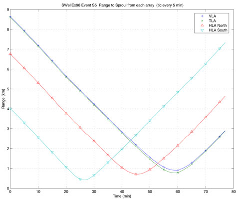
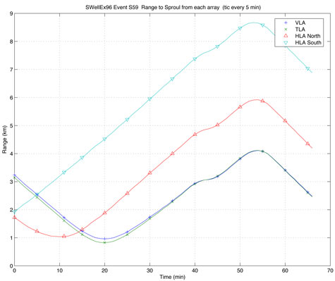
Two events of interest are described in this website: the S5 Event and the S59 Event. The S5 Event consisted of a source tow along an isobath and was devoid of loud interferers. The S59 Event also consisted of a source tow along an isobath but a loud interferer – a nearby surface ship – was present throughout the duration of the event.
Source-to-Receiver Range
Ranges from the towed source to the various receiving arrays have been calculated for each minute of the S5 and S59 Events and are available here courtesy of Dave Ensberg of the Marine Physical Lab. To download a tarball containing source position, source-to-receiver ranges, and a MATLAB M-file for calculating such, click here to download the file "range.tar" (80 KB). Below are figures summarizing that data.
GPS
The raw GPS data is also available for both the R/P FLIP (VLA location) and the R/V Sproul (source location). Onboard the R/P FLIP, a differential GPS system recorded GPS information for FLIP from 5/8/96, 16:52 GMT to 5/19/95, 15:00 GMT. Onboard the R/V Sproul, two GPS systems recorded GPS information for the source tow ship: a MicroMariner system recorded from 5/10/96 to 5/15/96 GMT, and a PCode system recorded from 5/11/96 to 5/15/96.
To download a tarball containing all of the GPS data, click here to download the file "gps.tar.gz" (1.8 MB).