
|
|
||||||||||
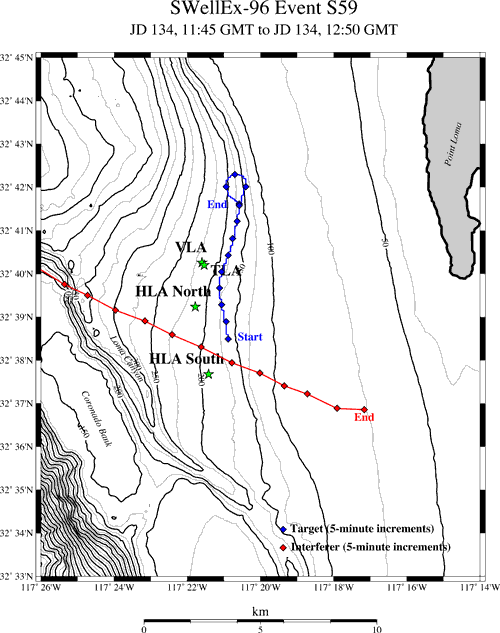
S59 Event
Event S59, like Event S5, is a source tow along as isobath during the SWellEx-96 Experiment. However, unlike Event S5, Event S59 contains a loud interferer. This is event is particularly useful for investigating the effects of a loud interferer on detecting/localizing a quiet target.
The source ship (R/V Sproul) began its track between and slightly east of the two HLA's and traveled at a speed of 5 knots (2.5 m/s) roughly northward along the 180 m isobath. During the last 25 minutes of the event, the tow ship bears to port and completes a loop.
The interferer of interest began west of the all of the arrays, proceeded southeast and between the two HLA's, and ended east of the arrays. A radar system aboard the R/P FLIP was videotaped, providing ranges and bearings between the interferer and the four arrays.
Sources
Two sources were simultaneously towed by the R/V Sproul: a "deep" source (J-15) and a "shallow" source (J-13).
The deep source was towed at a depth of about 54 m. It transmitted numerous tonals of various source levels between 49 Hz and 400 Hz. This tonal set is known as T-49-13. The T-49-13 tonal pattern consists of 5 sets of 13 tones. Each set of 13 tones spans the frequencies between 49Hz and 400Hz. The first set of 13 tones is projected at maximum level and is referred to as the "High Tonal Set." These tones are projected with transmitted levels of approximately 158 dB. The second set of tones are projected with levels of approximately 132 dB. The subsequent sets (3rd, 4th, and 5th) are each projected 4 dB down from the
previous set.T-49-13 Source Frequencies (Hz)
49 64 79 94 112 130 148 166 201 235 283 338 388 <-- High Signal Level
52 67 82 97 115 133 151 169 204 238 286 341 391 <-- 2nd Set of Tonals
55 70 85 100 118 136 154 172 207 241 289 344 394 <-- 3rd Set of Tonals
58 73 88 103 121 139 157 175 210 244 292 347 397 <-- 4th Set of Tonals
61 76 91 106 124 142 160 178 213 247 295 350 400 <-- 5th Set of TonalsThe shallow source was towed at a depth of about 9m. It transmitted 9 frequencies between 109 Hz and 385 Hz, known as the C-109-9S tonal set.
The C-109-9S Source Frequencies (Hz)
109 127 145 163 198 232 280 335 385 <-- Shallow Source FrequenciesSome initial post-processing utilized so-called "noise frequencies." Those frequencies chosen to be representative of the noise field are listed below:
Noise Frequencies Processed (Hz)
62 77 92 107 125 143 161 179 214 248 296 351 401As mentioned in the previous section, the interferer's position relative to the arrays can be determined using radar data and the program "geod." Below is an example of determining range and bearing between the interferer and the HLA North array. Aside: From the center of the HLA North array, the R/P FLIP is at a range of 1.9 km and at a bearing of 5 degs east of True North.
Using the radar data, we can find the range and bearing between the interferer and the R/P FLIP:
11:50
241
Using the "geod" program, the above information, and the a priori knowledge of FLIP's position, the latitude and longitude of the interferer can then be calculated. Similarly, the range and bearing from the interferer to the HLA North array can be computed (below).
Sensors
All four arrays (VLA, TLA, HLA North, and HLA South) recorded the full 65-minute event. The start time of Event S59 is J134, 11:45 GMT and it ends at J134, 12:50 GMT. Note: Day J134 corresponds to 5/13/96.
Environment
On J134, four CTDs were taken on the R/V LaSalsa. Of these, CTD #20 was the closest spatially (32d40.60' N 117d22.20' W) and temporally (13 May, 16:18 GMT) to the S59 Event. This sound speed profile has a weak mixing layer (~5 m) over a strongly downward refracting layer to about 40 m. The remainder of the profile is essentially isovelocity to the seafloor.
The sound speed data was salinity-despiked and depth-interpolated to every half meter.
The geoacoustic parameters were derived from a database of soundings and grainsizes. For more details on waveguide parameters, click on the "Environment" link in the navigation bar at the top of this page.Data
The array data below is in SIO format. The MATLAB M-file "sioread.m" can be used to read the data into MATLAB.
J1341145.vla.21els.sio.gz 297 MB 21-element subarray of the VLA J1341145.tla.22els.sio.gz 335 MB 22-element subarray of the TLA J1341145.hla.north.sio.gz 481 MB HLA North, bad elements removed J1341145.hla.south.sio.gz 499 MB HLA South, bad elements removed